Preparing a Grand Canyon itinerary is no easy task! When planning my road trip through the SouthWest region of the United States, I quickly decided to include the Grand Canyon on the list of places to visit. So far, this decision was easy. After all, the Grand Canyon is one of the most visited parks in the United States.
 1")
 2")
However, when I started researching what to do in the Grand Canyon, I was initially lost with so many options available. Which of the rims should I visit with little time to spare? Which trails to hike? How to get around the park? I had many questions and, after much research, I ended up focussing my visit on the South Rim of the Grand Canyon and the Grand Canyon East.
 3")
The Grand Canyon is divided into 4 parts: the South Rim, the North Rim, West Grand Canyon and East Grand Canyon. These 4 parts are quite different and offer different things to visitors. What’s more, not all of them can be visited all year round. For example, the North Rim is closed in the colder months.
The South Rim is the most popular part of the Grand Canyon, not least because it is the most easily accessible and has the best support infrastructures. When someone mentions the Grand Canyon, it’s usually the South Rim they’re referring to. Most of the photographs we see of this national park are taken here.
 4")
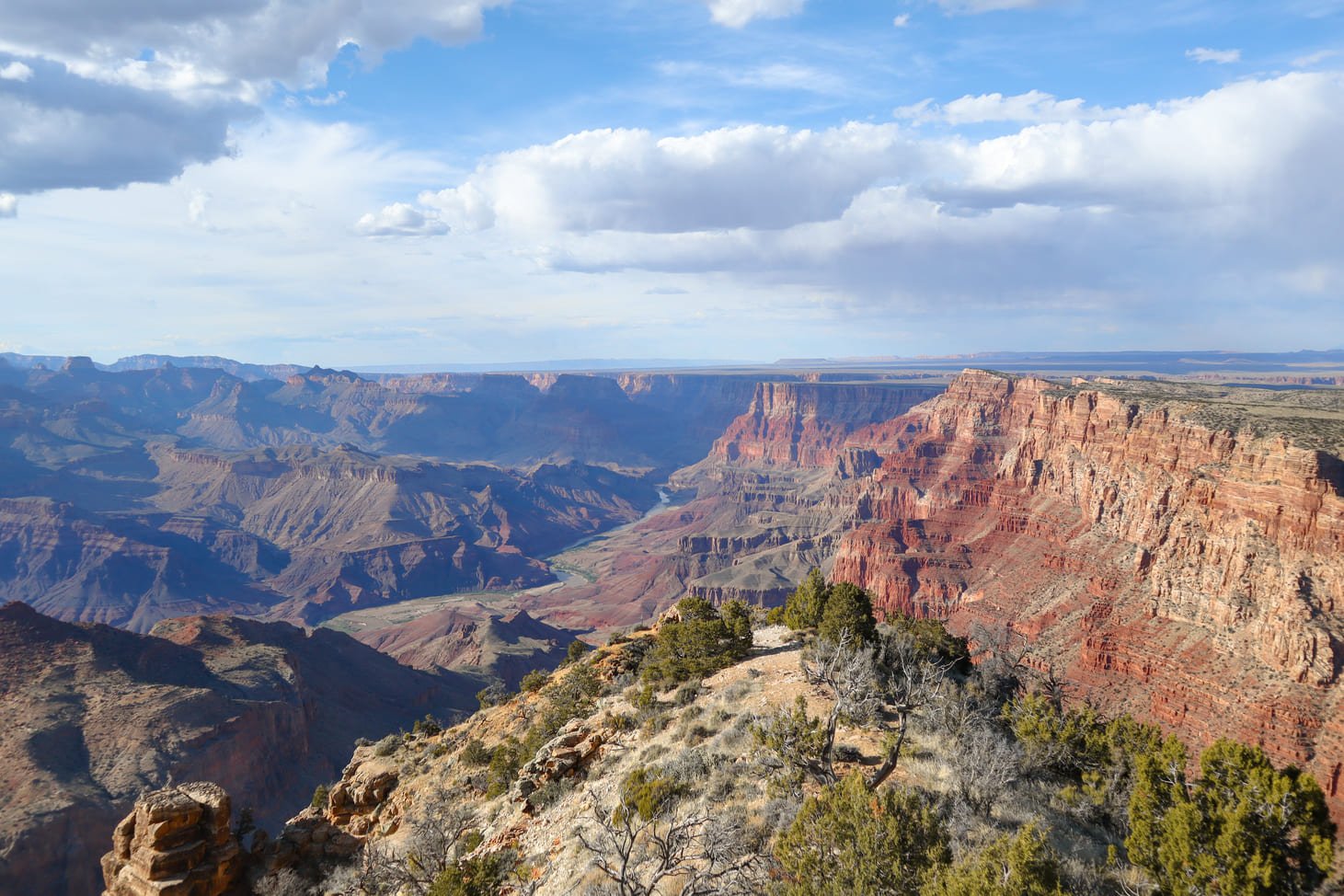
The Grand Canyon National Park is one of the most emblematic parks in the United States and is a UNESCO World Heritage Site and one of the 7 Natural Wonders of the World. You only have to visit one of the Grand Canyon’s many viewpoints to realise why this park has been awarded so many times.
I think that when you imagine the Grand Canyon, you think of something big and majestic. But the truth is that nothing prepares you for the vastness of the Grand Canyon. The park covers almost 5,000 square kilometres (1.2 million acres) 😱.
 5")
The Grand Canyon is formed by the Colorado River and is 446 kilometres (277 mi) long, up to 29 kilometres (18 mi) wide and has a maximum depth of 1.8 kilometres (1.1 mi).
So, throughout this article, you’ll find all the information you need on how to visit the Grand Canyon, such as:
- Best things to do in Grand Canyon
- How many days in Grand Canyon?
- Best months to visit Grand Canyon
- Lodges in Grand Canyon
- How to get to Grand Canyon
When is the best time to visit Grand Canyon?
Visiting the Grand Canyon is a great idea at any time of the year! The park has a lot to offer whatever the season.
The months with the most visitors are the summer months (June to September) and also the holiday season, such as Easter or Christmas. This is the worst time to visit the park because it’s when it’ll be more crowded, especially if you visit the South Rim, which is the most popular part of the park.
 6")
 7")
It’s no surprise that the Grand Canyon is one of the most visited national parks in the United States. In 2023, the park received almost 5 million visitors!!! If you visit during peak season, expect queues to enter the park and difficulty parking at some of the Grand Canyon’s attractions. In addition, the summer months are also the hottest, which can make the visit less enjoyable.
 8")
On the other hand, the winter months are when there are fewer visitors, but when temperatures are lower. In fact, it’s not that uncommon for it to snow in the Grand Canyon. What’s more, if you’d like to visit the North Rim, then you really should rule out a visit in winter, as this part of the park closes at this time. In 2024, for example, the North Rim was open from mid-May to mid-October. I recommend checking the official website to find out when the North Rim is open.
So, the best time to visit Grand Canyon is in spring (April and May) and autumn (September to November). For example, I visited in mid-April and the temperatures were pleasant, without being too cold or too hot. What’s more, although I came across several tourists in the park, I didn’t find it too crowded.
How many days to spend in Grand Canyon?
This is the question most people ask the moment they decide to visit the Grand Canyon 😝.
We could spend days (or even months) in Grand Canyon National Park that you wouldn’t be able to see it all! The park is almost 5,000 square kilometres (1.2 million acres)… I think that says it all.
 9")
 10")
However, you shouldn’t be discouraged, thinking that you can only visit the Grand Canyon if you have a lot of time on your hands. The good news is that you can visit Grand Canyon’s South Rim highlights and even a bit of Grand Canyon East in 2 or 3 days. This is exactly what I did in two days and what I’m going to recommend to you in this post.
Of course, if you have more time available, you could spend more time exploring the South Rim and doing some hiking or even going to more remote areas of the park like the North Rim. But the idea I really wanted to get across is that 2 to 3 days is a good trip duration to visit the Grand Canyon for first time visitors.
Where is the Grand Canyon?
The Grand Canyon is not an exact point on the map. In reality, the Grand Canyon National Park is divided into 4 parts, some of which are even a little distant from each other.
 11")
 12")
Even so, despite its enormous size, the Grand Canyon is located in the northernmost part of Arizona. The cities closest to the Grand Canyon depend on which part of the park we’re talking about:
- Grand Canyon East – Page
- Grand Canyon West – Las Vegas
- South Rim – Tusayan, Williams, Kingsman, Flagstaff, Sedona, Phoenix and Page
- North Rim – Jacob Lake
Which rim of the Grand Canyon is best?
The 4 zones of the Grand Canyon are the South Rim, North Rim, Grand Canyon East and Grand Canyon West. I’ve decided to put the 4 zones on a map so you can better understand their location.
 13")
South Rim
The South Rim is the most popular part of the park. This is where you’ll find some of the best viewpoints in the Grand Canyon and also some of the most popular trails. There’s a bit of everything on offer… from easily accessible viewpoints to quite demanding trails.
What’s more, this is one of the areas with the most support infrastructures, such as restaurants, shops and accommodation.
If you only have one day available to visit the Grand Canyon, then the South Rim is probably the best choice.
 14")
 15")
North Rim
On the other hand, the North Rim is one of the most remote areas of the Grand Canyon. The views are identical to the South Rim, except that you’ll find this part of the park much less crowded.
However, the North Rim is closed in the colder months (for example, in 2024 it was open from May to October), so if you’re visiting the park during the winter, this isn’t an option worth considering.
Grand Canyon East
On the east side of the Grand Canyon, you’ll find some of the most amazing landscapes, such as Horseshoe Bend or Antelope Canyon. Technically, this area is not part of the Grand Canyon National Park, but of the Glen Canyon National Recreation Area.
Take my word for it and believe me, it’s well worth trying to fit this area into your Grand Canyon itinerary!
Grand Canyon West
This is probably the most uninteresting part of the Grand Canyon, and its main attraction is the Skywalk – a viewpoint with a glass floor. The viewpoint looks nice, but it’s quite pricey (the cheapest ticket starts at 68 USD).
This is the part of the Grand Canyon that is closest to Las Vegas and therefore still receives quite a few visitors every year.
How to get to Grand Canyon?
The best way to get to Grand Canyon depends on the part of the park you wish to visit. There are a few regional airports in the area, but since most of these only offer a few domestic commercial flights, I’m only going to mention the closest airports to the Grand Canyon which offer international flights.
 16")
The main international airports closest to the Grand Canyon are:
- Phoenix Sky Harbor International Airport (Phoenix) – closest to the South Rim, Grand Canyon West and Grand Canyon East
- Harry Reid International Airport (Las Vegas) – closer to the Grand Canyon West
- Salt Lake City International Airport (Salt Lake City) – this is the furthest option of these 3
If you land at one of these airports, I suggest renting a car and driving to the Grand Canyon. Having a car will give you greater flexibility when travelling both inside and outside the park. Some companies also operate private flights between one of these airports and the more regional airports closer to the Grand Canyon (e.g. Grand Canyon National Park Airport, Flagstaff), which is an option worth considering.
 17")
 18")
💡 EXTRA TIP: When I visited Grand Canyon National Park, I was doing a road trip through other national parks in the United States. There’s no doubt that renting a car was the best option, as it gave me a lot of freedom to prepare my itinerary. I rented a Toyota RAV4 from Avis in Los Angeles and really enjoyed their service. Although I didn’t need this feature for what I visited in Grand Canyon National Park, I paid a bit more and decided to rent a high-clearance vehicle, which is an excellent option if you want to drive on some of the dirt roads that exist in the US national parks.
Another possible and different way to get to the Grand Canyon is to hop on a steam train on the Grand Canyon Railway, which departs daily from the historic town of Williams.
How much does it cost to visit the Grand Canyon?
You have to pay to enter Grand Canyon National Park. There are various entrance tickets and passes available. For example, entrance fees with a private vehicle are 35 USD (the price is per vehicle, not per person). This entrance fee gives you access to the park for 7 days! There is also an annual pass which costs 70 USD.
 19")
This Grand Canyon entrance ticket gives you access to both the South Rim and the North Rim. However, since the Grand Canyon West and Grand Canyon East areas are not technically part of the national park, you may have to pay extra to visit some of its main points of interest. This is the case with Antelope Canyon, the Skywalk or Horseshoe Bend, for example.
However, if you wish to visit other national parks in the United States, other options are more worthwhile. One such example is the America the Beautiful annual pass. This pass costs 80 USD per vehicle and is valid for one year for all the national parks in the country. Given the average price of entry to the various parks, you only need to visit 3 national parks in a year to make it worth buying America the Beautiful! More information about the passes is available here.
 20")
Any of these tickets or passes can be bought at the entrances to the various national parks. I would warn you, however, that most Grand Canyon ticket booths only accept card payments. You can also buy your entrance tickets online if you wish to spend less time queuing to enter the park😉.
If you choose to buy the America the Beautiful annual pass, once you’ve bought it, you’ll need to show your pass and ID when entering each park, as the pass is non-transferable.
💼 TRAVEL INSURANCE: Unexpected events happen anywhere in the world, so I always recommend getting travel insurance. I regularly use Heymondo, which offers some of the highest coverages on the market at very competitive prices. As well as covering medical expenses, Heymondo’s insurance also covers the loss or theft of luggage, electronic equipment and more. They also have a 24/7 customer service through their App. As A Ticket to Take Off reader, you get a 5% discount when purchasing Heymondo insurance. The purchase must be made using this link, and the price shown on the website already includes the discount.
Is there cell service in Grand Canyon?
Unlike other national parks in the United States where there is no mobile coverage, the Grand Canyon is different, especially at the South Rim where there are several support infrastructures.
Although the internet isn’t perfect and that reliable, compared to other parks, it works very well! Even so, as the service can fail, I suggest downloading the map of the area of the park you’re visiting so that it’s available offline on Google Maps.
What is the best way to visit the Grand Canyon (South Rim)?
Given the popularity of the South Rim of Grand Canyon National Park, shuttles travel along most of the roads in this part of the park. Some of these roads are closed to private vehicles for much of the year (e.g. Hermit Road). Using the shuttle is included in the park’s entrance ticket and it works on a first come first serve basis.
 21")
In any case, having a car will always come in handy when exploring other areas of the South Rim, such as Desert View Drive. What’s more, if you’re going to other parts of the Grand Canyon other than the South Rim, a car will also come in handy.
How do the shuttles operate at the Grand Canyon (South Rim)?
There are 4 shuttle lines in Grand Canyon National Park:
| Shuttle Line | First Shuttle | Last Shuttle | Frequency | General Info | Operating Hours |
|---|---|---|---|---|---|
| Village Route (Blue) | 6.30 am | 8.30 pm | 10 to 15 minutes (depends on the time of day) | Connects the Visitor Centre Shuttle Bus Terminal with some accommodation, restaurants and shops | All year round |
| Kaibab Rim Route (Orange) | 5 am | 8.30 pm | 15 minutes | The route is not circular and each direction stops at different places. | All year round |
| Hermits Rest Road (Red) | 8 am | 7 pm | 10 to 15 minutes (depends on the time of day) | The road along which this shuttle runs is closed from 1 March to 30 November. | 1st March to 30th November |
| Tusayan Route (Purple) | 8 am | 9 pm | 45 minutes | Shuttle serves the city of Tusayan and is an excellent way to get to the park for those staying in Tusayan | Early spring to autumn |
There is also a fifth shuttle (Hikers’ Express Shuttle) that runs only early in the morning, providing a direct connection between Grand Canyon Village and the South Kaibab Trailhead – one of the most popular trails on the South Rim.
As these timetables are subject to change and some of the lines don’t operate all year round, I strongly recommend that you check the most up-to-date information on the shuttles’ operating times beforehand.
I’m also sharing this map with the shuttle lines at the South Rim of the Grand Canyon to help you better plan your trip:
 22")
💡 EXTRA TIP: Given the influx of tourists at the Grand Canyon, it’s common to find long queues for the shuttles. So if you’re planning to start your day near the Visitor Centre, I suggest arriving early (before 9 am) so that you can find a parking space and don’t have to wait too long for the shuttle.
Parking in Grand Canyon (South Rim)
Although there are plenty of parking spaces next to the Visitor Centre, in the months with the most tourists in the park, spaces quickly run out. It’s therefore important to arrive early to secure a parking place!
Next to the Visitor Center there are 4 car parks available, as you can see in the image below.
 23")
If you arrive at the park and these spaces are already taken, I suggest you try to find parking near the Market Plaza or the Village Historic District. More information about parking at the Grand Canyon here.
Hotels in the Grand Canyon
The choice of accommodation in the Grand Canyon will depend on which part you want to visit. Since this itinerary only focuses on the South Rim and a few points of interest in the Grand Canyon East, I’m only going to mention accommodation for these two areas.
Accommodation to visit the South Rim
The first option, and probably the most expensive, is to stay inside the park at Grand Canyon Village in one of the existing lodges: Thunderbird Lodge, El Tovar, Bright Angel Lodge, Maswick Lodge or Kachina Lodge. These lodges have the advantage of being close to the shuttle bus, so you don’t need a car to visit most of the places of interest in the park.
Also very close to the park, you can stay in the town of Tusayan, which has several accommodation options:
 24")
 25")
 26")
However, even though it’s outside the park, the accommodation options in Tusayan are also quite expensive.
A third option is to look for accommodation in “nearby” towns such as Valle (50 km/30 mi), Red Lake (69 km/43 mi), Williams (100 km/60 mi) or Flagstaff (130 km/80 mi). In my case, I chose to stay in Williams at Motel 6 Williams. The room was clean and comfortable, but this was the most typical motel experience I had on my US road trip (and believe me, I stayed mostly in motels).
 27")
 28")
Finally, you can always decide to camp. To do so, I suggest you check out the official website for more information on camping at the Grand Canyon.
Accommodation to visit the Grand Canyon East
One of the best places to look for accommodation in the Grand Canyon East area is the town of Page. There are several accommodations and the town has good support facilities, particularly restaurants.
I stayed at Hyatt Place Page and really enjoyed it. The breakfast was varied and the rooms were spacious and modern.
Here are other accommodation options available in Page:
 29")
 30")
 31")
Is it possible to buy food inside the Grand Canyon?
Unlike other parks in the United States, it is possible to buy food and have meals inside Grand Canyon National Park, both at the South Rim and the North Rim. You can consult the existing restaurants available on the official website.
Activities & Tours in the Grand Canyon
There are lots of interesting activities you can do at the Grand Canyon. One of the most popular is undoubtedly taking a helicopter tour to observe the Grand Canyon from above.
This activity is on the pricey side, but it seems to be one of those “once in a lifetime” experiences 🥰. Everyone I’ve spoken to who has done this helicopter tour has really enjoyed it. For example, this tour has good reviews and includes a 45-minute helicopter flight.
Map of places to visit at Grand Canyon
To help you plan a trip to Grand Canyon National Park, I’ve put together its main points of interest on a map. On the map, you can find the best things to do in the Grand Canyon (South Rim) in one day and the main places of interest in the Grand Canyon East.
On the map, you can also see the location of the various stops on the South Rim shuttle lines.
📌HOW TO USE THE MAP: Click on the top left corner to access the various layers of the map. You can select the layers you’re interested in and also find out more about each point of interest by clicking on it in the left-hand sidebar or on the pin on the map. Add the map to your Google Maps by clicking on the star next to the title. To access the map, simply go to Google Maps ‘Saved’ and click on ‘Maps’!
Grand Canyon Itinerary: 2 days
The size of the Grand Canyon is extraordinary. We could spend days on end in the park and we wouldn’t be able to visit everything. However, for first-time visitors, 2 days is already a good trip length to visit two of the most beautiful areas of this incredible park.
So, I suggest distributing the time available over the 2 days as follows: 1 day at the South Rim and 1 day at the Grand Canyon East to visit Antelope Canyon and Horseshoe Bend. For me, this is one of the best ways to see the Grand Canyon, as it includes some of its most beautiful sights 😍.
 32")
 33")
Below you can find the itinerary separated into two days, but you can change the order of the days if it makes more sense for your overall itinerary.
This 2 day Grand Canyon itinerary assumes that you wake up near the South Rim on day 1 and head towards the Grand Canyon East on day 1.
Day 1 at Grand Canyon: South Rim
The South Rim is where you’ll find some of the best things you can do in the Grand Canyon. I’m talking about the almost endless viewpoints with magnificent views of the world’s most famous canyon and also the trails that allow you to see the park from another perspective.
 34")
With one day in the South Rim, you can visit most of the South Rim viewpoints and also hike part of the South Kaibab trail. There is one thing I should warn you: the photos below don’t do any justice to the true size of Grand Canyon! When I was there, at a certain point, I began to find all the viewpoints very similar, but there was one thing that never ceased to amaze me: the dimensions of the canyon.
South Kaibab Trail to Ooh Aah Point
Start the day early to hike part of the South Kaibab Trail. This is often considered the best hike in Grand Canyon. This is a trail that takes you below the rim, down to Colorado River. It’s quite a challenging trail, as the outward journey is mostly downhill and since this isn’t a loop trail, the return is mostly uphill.
 35")
 36")
The trail has amazing views almost the entire way! What’s more, this trail will offer you a unique opportunity to hike below the rim.
As time is limited, I suggest that you only hike this trail as far as the first viewpoint – Ooh Ahh Point. The round trip to this viewpoint is just 2.9 kilometres (1.8 mi). Allow about 2 hours for this short hike, which already includes time for some photos.
 37")
The South Kaibab Trail is very busy, so I recommend starting as early as possible. What’s more, in the warmer months, doing the trail earlier means you avoid the hottest hours.
Useful information about the trail:
- Start of the trail: South Kaibab Trailhead
- Access to this trail is via Yaki Point Road, which is not accessible by car. I recommend using one of the shuttles available for this purpose. If you start early, there’s the Hiker’s Express Shuttle which is more direct.
- Another way to get to the start of the trail is to leave your car on Desert View Road, which is open to private vehicles. However, you still have to walk a bit to the start of the trail. In my opinion, it makes more sense to use the shuttle.
- Distance to Ooh Ahh Point: 2.9 km (1.8 mi) round trip
- Moderate difficulty, as the way back is always uphill
💡EXTRA TIP: If you have more time available and would like to hike more of this trail, I suggest you check out the additional information about it. This is a demanding trail, so you should be prepared for it.
Visit some of the viewpoints along the Orange Route
Once the hardest part of the day is over, it’s time to start enjoying the Grand Canyon from different perspectives. There are many viewpoints on the South Rim and most are easily accessible.
Along the shuttle’s Orange Route there are a few viewpoints worth considering, especially as they are quite close to Grand Canyon Village.
 38")
The first viewpoint to consider is Mather Point, which is probably the best-known viewpoint in the park, as it is only a few metres walk from the Visitor Centre.
This viewpoint has a metal infrastructure that allows you to get close to the cliff, but although the view is beautiful, it’s not the best viewpoint because it’s always very crowded!
 39")
Another interesting viewpoint to consider is Yavapai Point. It’s about a 20-minute walk from Mather Point. In fact, one of the most fun ways to explore these viewpoints is via the Rim Trail. However, for the purposes of this itinerary, I suggest using the shuttle (orange line) to travel between these viewpoints.
💡 EXTRA TIP: Next to Yavapai Point you can also visit the Yavapai Geology Museum, where you can learn more about the geological formation of the Grand Canyon.
Yaki Point is another worth considering. If you start your day on the South Kaibab Trail, then visit Yaki Point first, as it’s located nearby. From this viewpoint, you can see part of the South Kaibab Trail.
 40")
In low season, it is also possible to drive along the road linking these viewpoints, but it can be difficult to find a parking space in some cases. However, Yaki Point is only accessible by shuttle bus all year.
💡 EXTRA TIP: As I visited in April and the park wasn’t that crowded, I ended up driving between the Visitor Centre and Grand Canyon Village, where you take the Red Route shuttle to Hermit Road. However, in high season I recommend using the blue shuttle to make the journey between these two points, as the parking spaces next to Grand Canyon Village fill up quickly.
Visit viewpoints on Hermit Road
Hermit Road is one of the most important roads on the South Rim. It runs for about 11 kilometres (7 mi), starting at Grand Canyon Village and ending at Hermit’s Rest.
 41")
This road is closed to private vehicles from 1 March to 30 November, so you have to use the Red Route shuttle to visit the viewpoints on this road almost all year round. Even in the months when it is possible to drive there with a private car, it is not always easy to find parking near the viewpoints.
 42")
 43")
I ended up visiting almost all the viewpoints on Hermit Road. Quite honestly, they’re all beautiful, but they end up looking identical after you’ve seen one or two. One of my favourites may have been the Mohave Viewpoint because you get a clearer view of the Colorado River.
These were the viewpoints I visited along Hermit Road:
- Trailview Overlook
- Powell Point
- Hopi Point – very popular for watching the sunset and sunrise in the Grand Canyon
- Mohave Point
- The Abyss
- Pima Point
 44")
Some viewpoints are relatively close to each other, so you can choose to do some parts of the road on foot, avoiding having to wait for the shuttle. For example, that’s what I did between Hopi Point and Powell Point, which are quite close together.
💡 EXTRA TIP: You can also explore this road by bicycle. Rental bikes are available in the park. As the shuttles also transport bicycles, you only need to cycle in one direction.
Visit viewpoints on Desert View Road
If you think the list of Grand Canyon viewpoints ends here, you’re wrong! There’s another road you can drive to find more opportunities to photograph the Grand Canyon.
The road is Desert View Drive on the eastern side of the South Rim, towards the park exit. This is the only part of the South Rim where there is no shuttle service available, so you can drive your own vehicle.
 45")
These were the viewpoints I visited along the Desert View Road:
- Grand View Point
- Moran Point
- Desert View Watchtower
Since these viewpoints are located on a road where you don’t need to use the shuttle, they are some of the most popular in the Grand Canyon. Especially the Desert View Watchtower, where there is a large car park and some support facilities, such as toilets, a restaurant and a shop.
 46")
You can climb to the top of the watchtower for panoramic views. More information here.
Although this is a very popular viewpoint, all you have to do is walk a bit away from the main area and you’ll find quieter areas where you can take photos without the crowds.
 47")
Day 2 at Grand Canyon: Grand Canyon East
The second day at the Grand Canyon will offer something very different from the landscapes you saw at the South Rim! The Grand Canyon East is spectacular, but it’s not here that you’ll find the typical Grand Canyon landscapes.
To optimise this itinerary, I suggest starting the day in Page, which is close to everything I’m going to suggest visiting in this part of the Grand Canyon. Remember that this area is not technically part of the Grand Canyon National Park.
Antelope Canyon
Even if you’ve never researched Antelope Canyon, I bet you’ve seen it as a Windows screensaver 😁. I was so curious about Antelope Canyon that it was one of the places I most wanted to visit on my road trip through the Southwest in the US.
And what a magnificent experience it was! Antelope Canyon is something really special, something you can hardly find anywhere else in the world. This slot canyon is formed by the erosion of rainwater.
Actually, we talk about Antelope Canyon, but there are two options: Upper Antelope Canyon and Lower Antelope Canyon.
 48")
 49")
Both are located in Page (Arizona) and can only be visited by guided tour. Given the popularity of these canyons, it’s best to book your visit as early as possible. There are several tours available (normal or photography tours), and the price also varies depending on the time of day you visit. At certain times of the day, you are more likely to see the phenomenon of light beams entering the canyon, making the visit more expensive.
The Upper Antelope Canyon is slightly more expensive and is the more popular of the two. I ended up visiting Lower Antelope Canyon and, at the time, the guide on our tour indicated that he actually preferred Lower Antelope Canyon because it was longer.
 50")
 51")
The tours last, on average, around 1.5 hours, and you get about 1 hour inside the canyon. The tours are with rather larger groups and so the canyon gets very crowded (which makes it difficult to take photos!), but the experience was marvellous nonetheless.
I booked this tour directly through Get Your Guide (the tour operator was Ken’s Tours) and I couldn’t recommend it more highly 😊. It was an experience I’ll never forget. It cost around 80€ per person.
Horseshoe Bend
Not far from Antelope Canyon, I also suggest visiting Horsehose Bend. This is a much-photographed landscape and one of the most popular along the Colorado River.
Admission to Horseshoe Bend is 10 USD per vehicle. Once you’ve passed the entrance, there’s a large car park and from there, it’s a few minutes’ walk to the viewpoint.
 52")
 53")
This is a very popular place, so don’t expect to be alone here. The best time to visit Horseshoe Bend is at sunrise and sunset, with sunset being the time of day when most people visit.
Although this place is visited by a large number of people, it’s easy to find an empty spot to take photos.
Kayak at Lake Powell
Another must-do in Page is a kayak trip around Lake Powell. This is a way of getting to know the region from a different and unique perspective. What’s more, kayaking is always fun. For example, this tour is highly rated and lasts 3h30.
💡 EXTRA TIP: If you have some extra time, and depending on your next destination, you can drive a bit of Route 66, passing some of the road’s emblematic sites such as Williams, Kingsman or Seligman.
 54")
 55")
Tips for hiking in Grand Canyon
Although I haven’t mentioned many trails throughout this article, the truth is that there are some very interesting options in this park (such as the South Kaibab Trail or the Bright Angel Trail). However, some of these trails are quite demanding, so I’ll leave you with some of the park’s official recommendations.
Some trails are so demanding that there are several rescue operations. So make sure you follow the park’s official recommendations:
- Protect from the sun with a hat, sunglasses, light clothing and sun cream.
- Ensure the necessary hydration while hiking any trail, especially if you’re hiking below the rim.
- Plan your visit in advance to avoid going on the trails at the hottest time of the day.
- On days with fewer hours of daylight, make sure you return from the trail when there is still light since it gets dark earlier.
- If you’re going to walk a trail alone, tell someone you know that you’re doing it.
- Plan your return to your car according to the departure time of the last shuttle of the day.
- Know where you can park your car and which shuttles (and their stops) to use to get to the start of the trails.
 56")
Finally, don’t forget the Leave No Trace principle, by complying with its 7 principles: prepare your visit in advance, dispose of rubbish in appropriate places, leave everything the same way as you found it, minimise the impact of any campfires, respect wildlife, be respectful to other visitors and comply with the camping rules.
Disclaimer: this post may contain some affiliate links, which means I get a small commission if you buy something through my links. This doesn’t represent any additional cost to you and you’ll be supporting my work here on the blog😊